Water Quality Monitoring
(Based in Gdańsk)


Water Quality Monitoring
(Based in Gdańsk)
Monitoring jakości wody
(Based in Gdańsk)
Autonomous
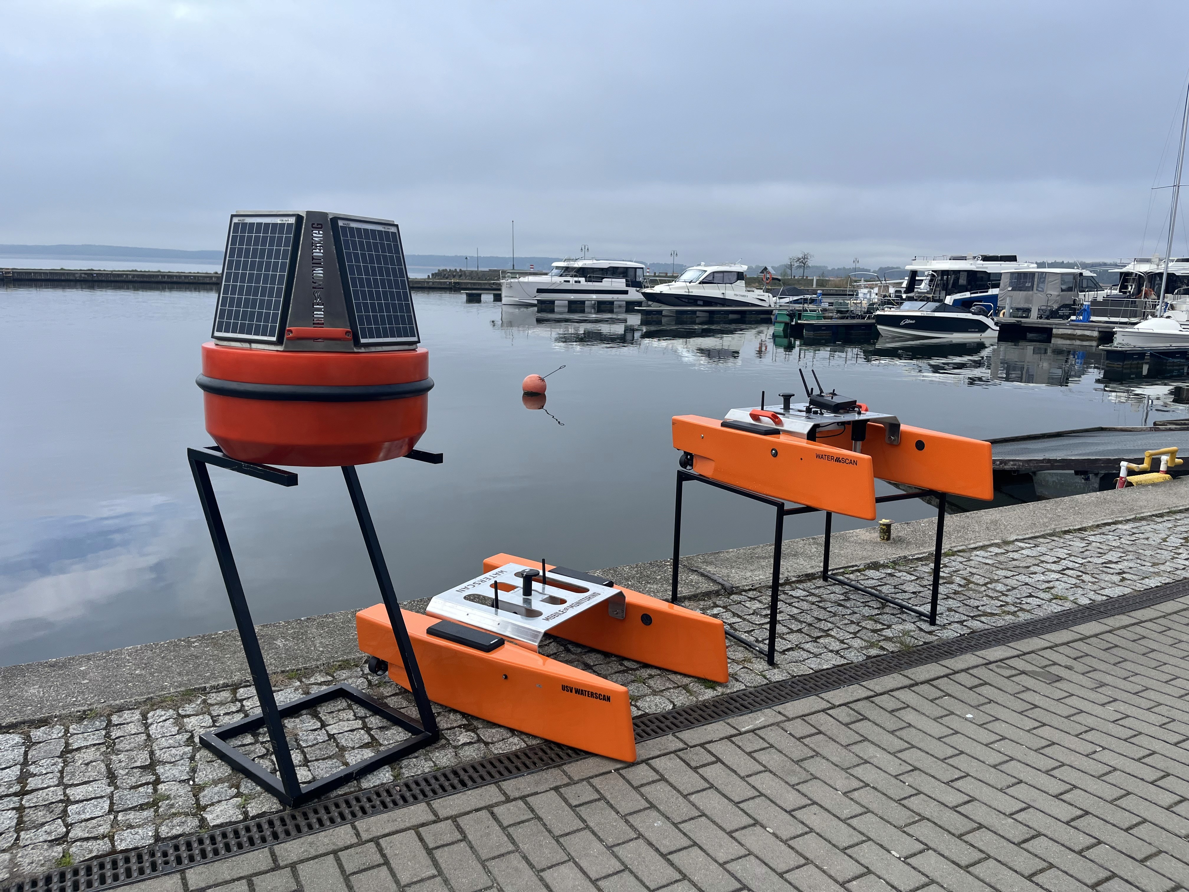
USV Water Drones

{01} — technology and tools
What is a USV drone?
The USV drone is an unmanned surface vehicle designed for autonomous or remotely controlled water operations. Equipped with advanced sonar systems, it enables seafloor mapping. Its compact design and cutting-edge technology make it the perfect tool for operating in challenging and inaccessible areas.


{02} — technology & advantages
Advantages of the USV Drone
{02} — technology & advantages
Advantages of the USV Drone
{02} — technology & advantages
Advantages of the USV Drone

Measurement Accuracy:
A surface drone equipped with sensors for measuring water quality enables advanced real-time environmental analysis. With sonar, it also allows for bathymetric measurements and bottom mapping to support hydrography, water engineering and scientific research activities.
Measurement Accuracy:
A surface drone equipped with sensors for measuring water quality enables advanced real-time environmental analysis. With sonar, it also allows for bathymetric measurements and bottom mapping to support hydrography, water engineering and scientific research activities.
Measurement Accuracy:
A surface drone equipped with sensors for measuring water quality enables advanced real-time environmental analysis. With sonar, it also allows for bathymetric measurements and bottom mapping to support hydrography, water engineering and scientific research activities.

Operational Efficiency:
With its ability to operate autonomously, the USV drone eliminates the need for crew presence on the water. This significantly enhances operational efficiency while simultaneously reducing costs and risks associated with working in challenging conditions.
Operational Efficiency:
With its ability to operate autonomously, the USV drone eliminates the need for crew presence on the water. This significantly enhances operational efficiency while simultaneously reducing costs and risks associated with working in challenging conditions.
Operational Efficiency:
With its ability to operate autonomously, the USV drone eliminates the need for crew presence on the water. This significantly enhances operational efficiency while simultaneously reducing costs and risks associated with working in challenging conditions.

Access to Challenging Areas:
It can operate in locations that are inaccessible to traditional vessels. Its ability to maneuver in tight and shallow waters makes it indispensable for exploring hard-to-reach areas.
Access to Challenging Areas:
It can operate in locations that are inaccessible to traditional vessels. Its ability to maneuver in tight and shallow waters makes it indispensable for exploring hard-to-reach areas.
Access to Challenging Areas:
It can operate in locations that are inaccessible to traditional vessels. Its ability to maneuver in tight and shallow waters makes it indispensable for exploring hard-to-reach areas.
01
Measurement Sensor
02
USV Drones
03
ROV Drones
04
AI Cameras
04
AI Cameras

{03}
Capabilities of USV Drones
Survey
/
01
Environmental Monitoring
pH & Salinity Scan:
Measurement of physico-chemical parameters of water
Temperature Logging:
Continuous Temperature Recording
Pollution Detection:
Water Contamination Identification
/🌊 Scientific Grade/
Survey
/
01
Environmental Monitoring
pH & Salinity Scan:
Measurement of physico-chemical parameters of water
Temperature Logging:
Continuous Temperature Recording
Pollution Detection:
Water Contamination Identification
/3-5 weeks/
Survey
/
01
Environmental Monitoring
pH & Salinity Scan:
Measurement of physico-chemical parameters of water
Temperature Logging:
Continuous Temperature Recording
Pollution Detection:
Water Contamination Identification
/🌊 Scientific Grade/
Tracking
/
02
Monitoring
Movement Analysis:
Monitoring of pH, TDS, ORP, Nitrogen, Petroleum Substances
Ecosystem Monitoring:
Continuous access to environmental insights
Threat Identification:
Detection of Contaminants and Biological Changes
/📡 Real-time Data/
Tracking
/
02
Monitoring
Movement Analysis:
Monitoring of pH, TDS, ORP, Nitrogen, Petroleum Substances
Ecosystem Monitoring:
Continuous access to environmental insights
Threat Identification:
Detection of Contaminants and Biological Changes
/📡 Real-time Data/
Tracking
/
02
Monitoring
Movement Analysis:
Monitoring of pH, TDS, ORP, Nitrogen, Petroleum Substances
Ecosystem Monitoring:
Continuous access to environmental insights
Threat Identification:
Detection of Contaminants and Biological Changes
/📡 Real-time Data/
Sonar
/
03
Asset Localization
Side Scan Sonar:
Scanning the seabed and obstacles
Object Detection:
Localization of underwater structures and objects
Rescue Support:
Support in search and rescue operations
/🛰️ High Precision/
Sonar
/
03
Asset Localization
Side Scan Sonar:
Scanning the seabed and obstacles
Object Detection:
Localization of underwater structures and objects
Rescue Support:
Support in search and rescue operations
/🛰️ High Precision/
Sonar
/
03
Asset Localization
Side Scan Sonar:
Scanning the seabed and obstacles
Object Detection:
Localization of underwater structures and objects
Rescue Support:
Support in search and rescue operations
/🛰️ High Precision/
Logistics
/
04
Transport
Payload Delivery:
Transportation of samples and research equipment
Remote Deployment:
Delivering to Hard-to-Reach Areas
Safe Operations:
Operations up to 7 kg over short distances
/🚢 Short-range Cargo/
Logistics
/
04
Transport
Payload Delivery:
Transportation of samples and research equipment
Remote Deployment:
Delivering to Hard-to-Reach Areas
Safe Operations:
Operations up to 7 kg over short distances
/🚢 Short-range Cargo/
Logistics
/
04
Transport
Payload Delivery:
Transportation of samples and research equipment
Remote Deployment:
Delivering to Hard-to-Reach Areas
Safe Operations:
Operations up to 7 kg over short distances
/🚢 Short-range Cargo/
Mapping
/
05
Bathymetry
Sonar Scanning:
Single-beam seabed mapping
Depth Profiling:
Comprehensive Environmental Analysis
Engineering Use:
Data for Engineering Applications
/🧭 Bathymetric Mode/
Mapping
/
05
Bathymetry
Sonar Scanning:
Single-beam seabed mapping
Depth Profiling:
Comprehensive Environmental Analysis
Engineering Use:
Data for Engineering Applications
/🧭 Bathymetric Mode/
Mapping
/
05
Bathymetry
Sonar Scanning:
Single-beam seabed mapping
Depth Profiling:
Comprehensive Environmental Analysis
Engineering Use:
Data for Engineering Applications
/🧭 Bathymetric Mode/
Custom
/
06
Specialized Tasks
Modular Design:
Capability to integrate additional modules
Sensor Integration:
Magnets, detectors, sensors, GPS
Mission Ready:
Customization for specific needs
/🛠️ Mission Flexible/
Custom
/
06
Specialized Tasks
Modular Design:
Capability to integrate additional modules
Sensor Integration:
Magnets, detectors, sensors, GPS
Mission Ready:
Customization for specific needs
/🛠️ Mission Flexible/
Custom
/
06
Specialized Tasks
Modular Design:
Capability to integrate additional modules
Sensor Integration:
Magnets, detectors, sensors, GPS
Mission Ready:
Customization for specific needs
/🛠️ Mission Flexible/